
A cyclone, moving at a speed of 3 kilometres per hour towards to coast of Pakistan and India, is likely to have an extreme atmospheric impact on the coastal areas of the adjoining countries, prompting the authorities on both sides to carry out mass exodus from the settlements near the sea.
As per the latest forecast, the cyclone — named Biparjoy, meaning “disaster” in Bengali — in the Arabian Sea is categorised as a very severe cyclonic storm (VSCS).
It has moved nearly northwards during the last six hours and is currently positioned near latitude 21.9°N and longitude 66.3°E, about 280 km west-southwest of Jakhau Port (Gujarat) and 340 km south-southwest of Karachi.
It is very likely to move nearly northeastwards today and then recurve northeastward and cross between Keti Bandar and adjoining Indian coasts between Karachi and Mandvi (Gujarat) near Jakhau Port (Gujarat) by the evening of June 15 as a VSCS with a maximum sustained wind speed of 125-135 kmph gusting to 150 kmph.
Mass evacuations are underway in the coastal areas of both countries, and the authorities remain high alert as the cyclone inches closer.
There is a high risk of coastal inundation in the areas near the coastline, including Karachi, Thatta, Sujawal, and Badin, while the Indian Met department warns of torrential rains with thunderstorm under the impact of Biparjoy.
Fishermen are advised not to venture into the open sea till the system is over by 17 June, as the sea level has risen to a dangerous level along the coastal belt, and the Arabian Sea conditions are very rough.
— Widespread wind-dust/thunderstorm rain with some very heavy/extremely heavy falls accompanied with squally winds of 80-100kmph gusting 120kmph likely in Thatta, Sujawal, Badin, Tharparker, Mirpurkhas and Umerkot districts during 13-17 June.
— Dust/thunderstorm-rain with few heavy falls & accompanied with squally winds of 60-80 Km/hour likely in Karachi, Hyderabad, Tando Muhammad Khan, Tando Allayar, Shaheed Benazirabad & Sanghar districts from 14 -16 June.
— Dust/thunderstorm-rain with isolated heavy falls likely in Hub, Lasbella districts of Balochistan during 14-16 June.
— Squally (high intensity) winds may cause damage to loose & vulnerable structures (Kutcha houses) including solar panels etc.
— Storm surge of 3-3.5 meters (8-12 feet) expected at the land falling point (Keti Bandar and around) which can inundate the low-lying settlements.
— Sea conditions along Sindh coast may get very rough to high (2-2.5 meter) accompanied and rough to very rough (2 meter) along Balochistan coast (Sonmiani, Hub, Kund Malir. Ormara and surroundings).
Possible impacts on Indian coastal areas:
— Light to moderate rainfall at most places with heavy to extremely heavy rainfall at isolated places very likely over Kachchh, Devbhumi Dwarka, Porbandar, Jamnagar, Rajkot, Junagarh and Morbi districts of Saurashtra and Kutch on June 14.
— The intensity of rainfall would increase with heavy to very heavy rainfall at a few places and extremely heavy falls at isolated places very likely over Kachchh, Devbhumi Dwarka & Jamnagar and heavy to very heavy rainfall in districts of Gujarat and isolated heavy to very heavy rainfall is very likely over remaining districts of Saurashtra and north Gujarat region on June 15th.
— Light to moderate rainfall at most places with heavy to extremely heavy rainfall at isolated places very likely over north Gujarat and adjoining south Rajasthan on June 16 and southeast Rajasthan & adjoining North Gujarat region on June 17.
Key updates on cyclone:
NDMA urges people to stay cautious and safe
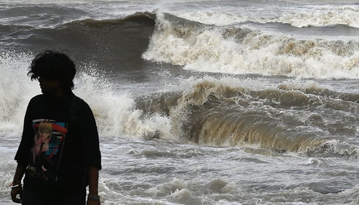
Rough sea conditions intensify at Hawkes Bay
The sea conditions have intensified at Karachi’s Hawkes Bay as high waves are crashing on the beach. Despite the sea water reaching the road along the coast, there is no one to prevent people from visiting the beach.
Light to moderate rain expected in Karachi today
Sindh Chief Meteorologist Sardar Sarfaraz on Tuesday said that light to moderate rain is expected in Karachi today, while heavy showers are likely on Thursday and Frida


